Design a site like this with WordPress.com
Get started

Patagonia: Torres del Paine National Park, Chile

7 January 2011: Argentina to Chile

 Torres del Paine National Park
Torres del Paine National Park
 Old truck at lunch stop in Esperanza
Old truck at lunch stop in Esperanza

A whole day of driving. From El Calafate we cross into Chile today and will spend the next few days in Torres del Paine National Park, arguably the highlight of this trip, but I think they are all equally awesome. We took Ruta Nacional 40 in the loop towards the border, stopping for lunch and bit of sightseeing in the small town of Esperanza, then westwards on small highway 7 and joining back to Ruta 40 again. 

At the border crossing, the Argentian side is just a few buildings in the middle of nowhere, easily a km away from the actual border. Passport control was simple enough, we just had to queue up behind a bus that was coming in from Chile. In Chile, we got onto a road called Y205 and after 3km drive, we come to the border crossing, where luggage scan and passport control was required. The border post in Chile, in fact even the road here, seems much better than the part in Argentina. This border crossing is in a small town, and when I checked on google maps after the trip, it seems to say that the town is also called Torres del Paine. There’s a souvenir store next to the immigration booth, which is just swell as bus load of tourists can shop while waiting for their cohorts to finish the formalities. 

 Before Lago Sarmiento, when the road goes from paved to gravel and with the Cordillera in the background. On the road up ahead is part of the group walking around looking for things to shoot.
Before Lago Sarmiento, when the road goes from paved to gravel and with the Cordillera in the background. On the road up ahead is part of the group walking around looking for things to shoot.

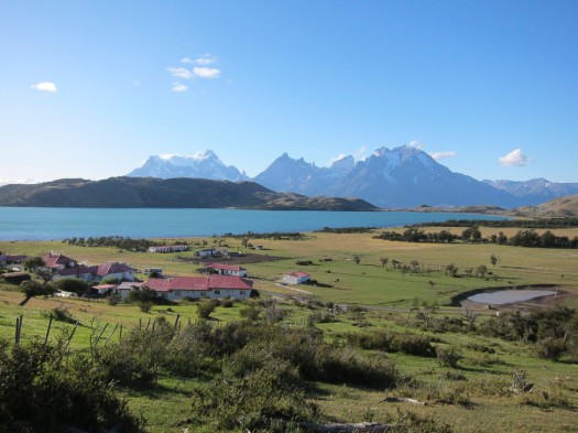
First stop is our stay for the night at Laguna Verde, but first I got the first glimpse of what I was about to see over the next few days, including a drive past Lago Sarmiento and onto gravel road before reaching Estancia Lazo on the banks of Laguna Verde. Its a working ranch in a really pretty (and I don’t usually use that word) by the banks of Laguna Verde. Spent the rest of the day and the next morning exploring the banks and taking pictures of the laguna in the foreground and with Cordillera del Paine in the background. I can stay here forever. 

 Estancia Lazo with Torres del Paine peaks in the background behind Laguna Verde. This was taken during a photographic survey, looking for the best vantage point for that evening and the next morning.
Estancia Lazo with Torres del Paine peaks in the background behind Laguna Verde. This was taken during a photographic survey, looking for the best vantage point for that evening and the next morning.
 Laguna Verde at the water line. Notice the strength of the wind whipping up waves. I think I took one of my favourite shots here the next morning with the pebbles in the foreground on a wide angle lens.
Laguna Verde at the water line. Notice the strength of the wind whipping up waves. I think I took one of my favourite shots here the next morning with the pebbles in the foreground on a wide angle lens.
 Trees in this part of the world grow in strange shapes, primarily caused by exposure to strong winds.
Trees in this part of the world grow in strange shapes, primarily caused by exposure to strong winds.
 Evening setup from the hotel room for a whole night of star trails shooting.
Evening setup from the hotel room for a whole night of star trails shooting.
 Good morning, Laguna Verde!
Good morning, Laguna Verde!

8 January 2011: Laguna Verde to Lago Grey 

 Stromatolites along the shores of Lago Sarmiento. These are calcium deposits that are found all around the shore of this lake. Read up on it online. 
Stromatolites along the shores of Lago Sarmiento. These are calcium deposits that are found all around the shore of this lake. Read up on it online. 
 First closeup view of the Cordilleras while driving along Lago Nordenskjol. 
First closeup view of the Cordilleras while driving along Lago Nordenskjol. 

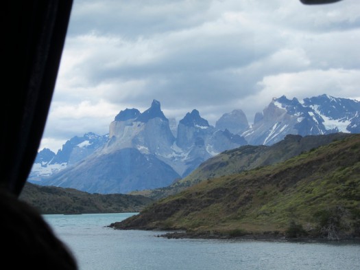
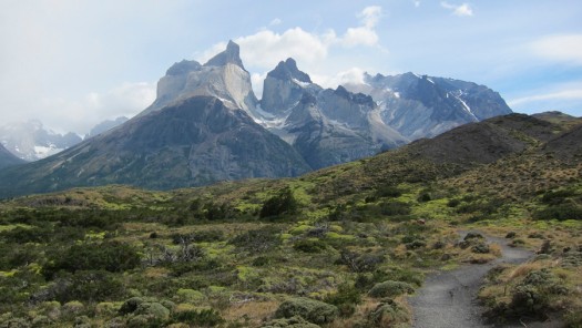
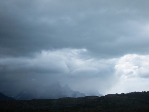
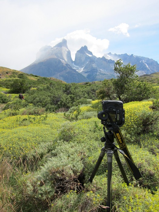
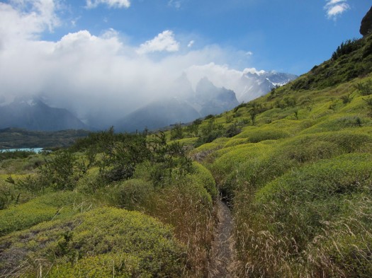
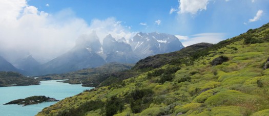
I don’t know, I think today is one of the best drive in my whole life. No joke. Today we drive around Lago Sarmiento and right by the masterpiece of the park, the Cordillera del Paine peaks while going along Lago Nordenskjol, Lago Pehoe where I think some of the best sights are to be found, and then skirting the end of Lago del Toro and ending at Lago Grey. They call the main bit, which is the one with the black top the Cuernos (the horns). Not to mention the countless stops that we made to chase guanacos, and condors. The only thing we didn’t see today was the puma. 

 Rickety bridge across Rio Grey, close to Lago Grey
Rickety bridge across Rio Grey, close to Lago Grey

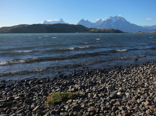
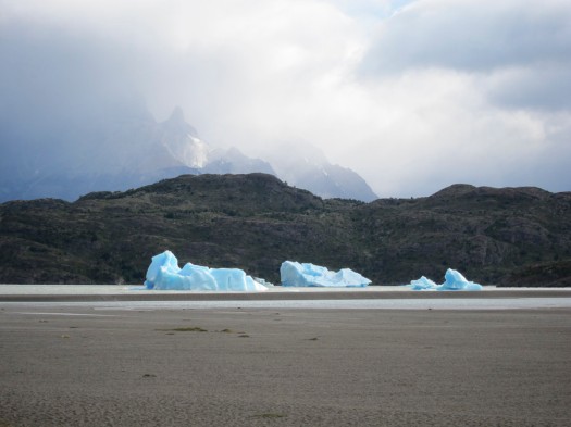
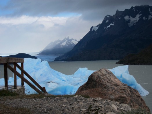
Lago Grey is fed by Glaciar Grey, and ice from the glacier breaks off and gets sent by the strong Patagonian winds to the south bank, which is where Hosteria Lago Grey is located. The air here is decidedly cold, and the hotel has just recently been renovated, and it is probably one of the most upscale place that I’m staying in so far in this trip. 

 Rooms at Lago Grey. The light from the windows were blown out, otherwise the icebergs would be visible outside.
Rooms at Lago Grey. The light from the windows were blown out, otherwise the icebergs would be visible outside.

At Lago Grey, you can see icebergs on the beach, and on a good day, one could take a walk along a sand bank onto a small island. 

9 January 2011: Lago Grey

Today is a full Lago Grey day. While I tried to take the walk along the beach, the weather is not cooperating… strong winds, and light rain pounded us the whole day. The wind blew away the plastic cover that covers my backpack. Looks like I will have to come back again sometime in the future. Oh, and I did spot a rare Patagonian Huemul (deer) here on the way back to the Hosteria… call it a lucky day.

 Just in case you get lost at Lago Grey. But there's not much of a path to get lost here.
Just in case you get lost at Lago Grey. But there’s not much of a path to get lost here.
 Icebergs of Lago Grey. Note the incoming storm.
Icebergs of Lago Grey. Note the incoming storm.
 On the small island on the southern end of Lago Grey. Grey's Glacier is visible in the distance.
On the small island on the southern end of Lago Grey. Grey’s Glacier is visible in the distance.
 Incoming storm starting to obscure the Cordillera del Paine peaks. Can't get great weather all the time... too bad.
Incoming storm starting to obscure the Cordillera del Paine peaks. Can’t get great weather all the time… too bad.

10 January 2011: Las Torres

 The Cuernos in the clouds taken on the way from Lago Grey to Salto Grande. I think this is where I took one of my favourite shots of the trip.
The Cuernos in the clouds taken on the way from Lago Grey to Salto Grande. I think this is where I took one of my favourite shots of the trip.
 Along Lago Pehoé. I think the views here are stunning because of the colour of the lake, and the surreal shape of the peaks in the background. It was a cloudy day but with a bit of patience, it was possible to get a nice shot.
Along Lago Pehoé. I think the views here are stunning because of the colour of the lake, and the surreal shape of the peaks in the background. It was a cloudy day but with a bit of patience, it was possible to get a nice shot.
 Shooting the Cuernos from the banks of Lago Nordenskjol.
Shooting the Cuernos from the banks of Lago Nordenskjol.
 Salto Grande waterfall, joining Lago Nordenskjol and Laho Pehoé.
Salto Grande waterfall, joining Lago Nordenskjol and Laho Pehoé.

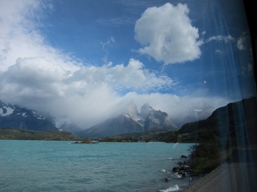
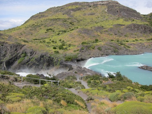
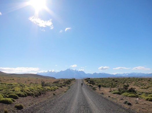
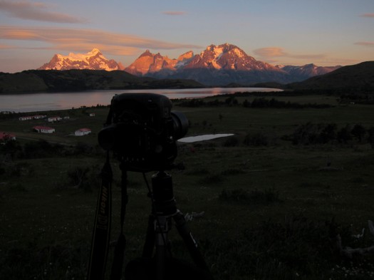
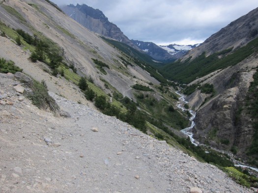
From the western end of the national park, we drive today again past the central Lago Pehoe while stopping for photo opportunities whenever we could. There’s time to take a walk up to Mirador Pehoé, and a short hike past Salto Grande waterfall for the view of Cordillera del Paine across Lago Nordenskjol. The best time is probably early in the morning or in the evening, and I was there during the noon sun – but the scenery here is so beautiful I don’t mind. Again, the winds here are crazy strong. Don’t bring anything that flaps in the wind since it will probably not stay on you for a long time.

 At Mirador Pehoé. Normally a easy hike after lunch, but made extremely comfortable because of the shrub with the spiky leaves. I found a couple of the spikes in my shoe months after the trip. I call it the asshole plant. Because it is.
At Mirador Pehoé. Normally a easy hike after lunch, but made extremely comfortable because of the shrub with the spiky leaves. I found a couple of the spikes in my shoe months after the trip. I call it the asshole plant. Because it is.
 And this is the result, and mind you this is a panorama from a Canon S95.
And this is the result, and mind you this is a panorama from a Canon S95.

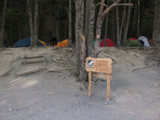
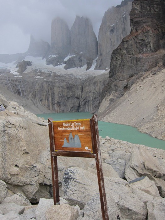
The next few nights, and the last stop is at Hotel Las Torres, a large estancia that has been converted into a resort. This si the closest hotel you will get to the start of the trek up to Mirador Las Torres, our last strenuous climb. 

 Guanacos on the way to Las Torres. Notice the sharp triple peaks in the background? That's where we're heading on tomorrow's hike.
Guanacos on the way to Las Torres. Notice the sharp triple peaks in the background? That’s where we’re heading on tomorrow’s hike.
 After the transfer into smaller cars, heres the squeeze through the narrow bridge.
After the transfer into smaller cars, heres the squeeze through the narrow bridge.

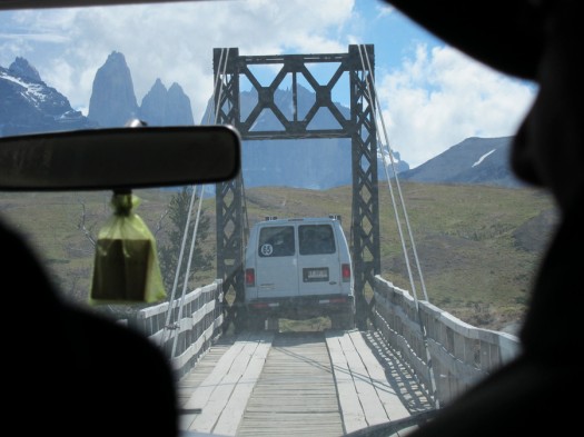
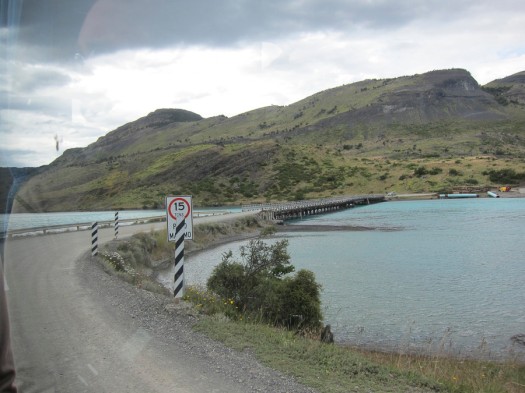
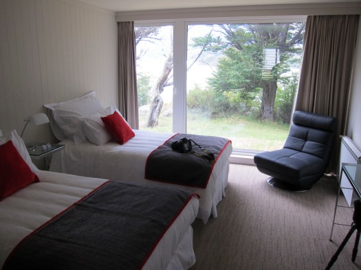
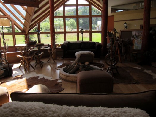
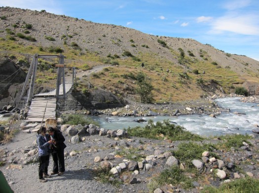
The final section of the drive to Las Torres requires that we get off the small bus and transfer to hotel SUV for the drive across a narrow bridge that barely clears the side mirror of the SUV. The hotel has a proper lobby and just about any convenience that you would expect, or not expect in the middle of the wilds of Torres del Paine. It feels that you are not in an adventure while staying here. Its just too comfortable. Maybe there’s a reason for that, the trek tomorrow would be 9km and 800m elevation gain up to Mirador del Torres and back down again. 

 Las Torres lobby
Las Torres lobby

No need to mention about the food here. Steak… You will gain weight.

 Not my usual food picture... check out the chunk of meat. Cut to measure, Patagonian style.
Not my usual food picture… check out the chunk of meat. Cut to measure, Patagonian style.

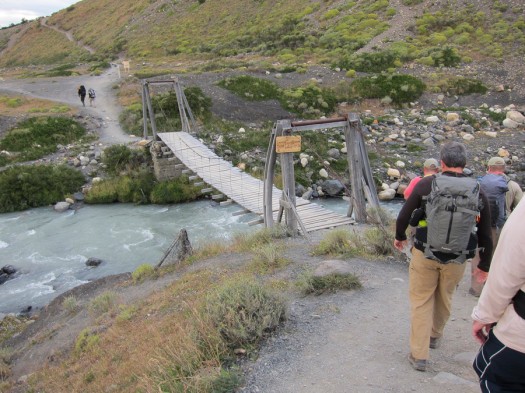
11 January 2011: Mirador Las Torres

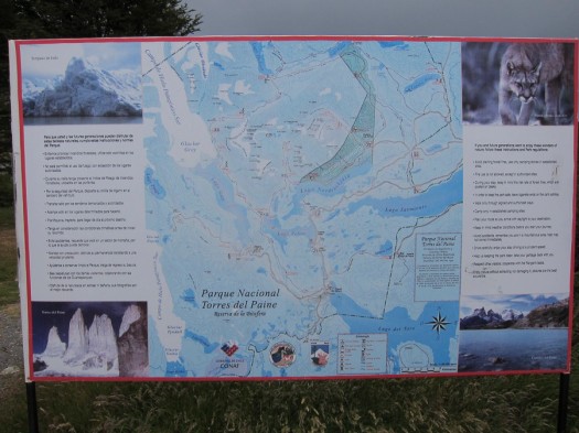
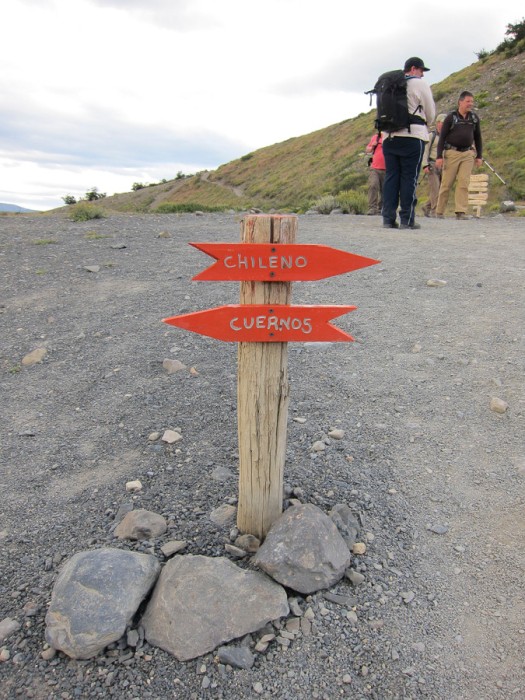
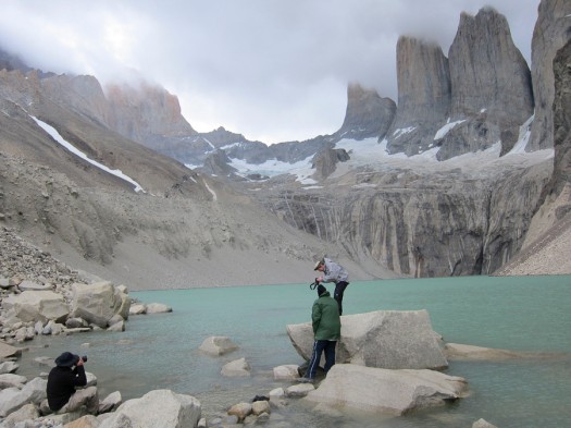
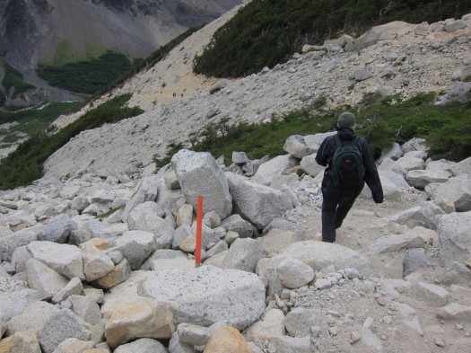
I will not describe the trek in too much detail. Apparently most of the trek is over private land, and you walk along the valley will you get to the base when it becomes a boulder climb up hundreds of meters before you get to the mirador, which is a glacial lake on the top of the mountain – where you realise that the whole trek was well worth the view. I packed sandwich lunch and some fruits so this is a good place to take a break and enjoy a view that I probably not get to see again for some time. 

 On a great day, start of the trek up to Mirador Las Torres
On a great day, start of the trek up to Mirador Las Torres
 First junction
First junction
 Trekking along the valley, it doesn't look as scary as this picture. But its not fun to fall, I agree.
Trekking along the valley, it doesn’t look as scary as this picture. But its not fun to fall, I agree.
 Plenty of camping area
Plenty of camping area
 Water bottle refill zone
Water bottle refill zone
 Almost at the end of the trek, now all there is left is to climb to the top of the glacial lake
Almost at the end of the trek, now all there is left is to climb to the top of the glacial lake
 ... looking back
… looking back
 Almost there...
Almost there…
 And voila!!!
And voila!!!
 The large boulders makes it difficult to move around but it is possible to get close to the lake for a souvenir shot
The large boulders makes it difficult to move around but it is possible to get close to the lake for a souvenir shot
 Time for a break
Time for a break

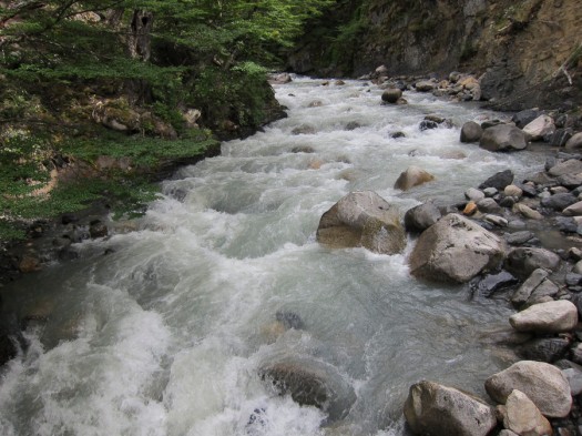
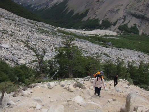
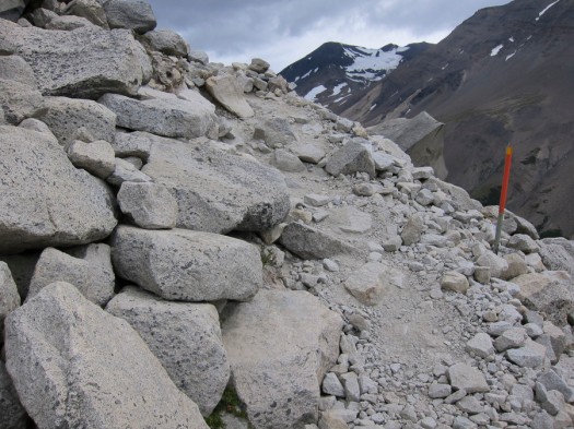
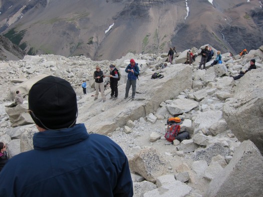
I guess the trek is not as difficult as I made it out to be. I think the trek at Cerro Torre was more difficult even though the elevation gain was not as bad, mainly because it was hotter then. On top of that, my backpack was choke full of camera gear and a mid size tripod. There was not too much water since I replenished it along the way in the stream. 

 Going down, not really easier as it really kills my knee
Going down, not really easier as it really kills my knee
 The GPS helps to tell how far left to get to the hotel
The GPS helps to tell how far left to get to the hotel

 After a long day of hiking, this bridge was the best sight as it signalled that we were close to the hotel
After a long day of hiking, this bridge was the best sight as it signalled that we were close to the hotel

Needless to say once I got back to Las Torres later in the day, dinner never tasted so good. The buffet dinner comes with a big chunk of beef that is cut to order, and I asked for a double thickness chunk of meat. Well deserved. 

 And finally!
And finally!

Great end to an amazing photographic holiday. Or so I thought…

Patagonia: El Calafate, Santa Cruz, Argentina

 DSC2031-2011-01-7-05-28.jpg
DSC2031-2011-01-7-05-28.jpg

Flamingoes on Lago Argentino

6 January 2011

El Calafate is the largest town here at Parc Nationale de Glacieriares but it is still a small town with tens of thousand inhabitants. It is named after Calafate berry that is close to blueberry and make very good jam and sorbet. I know because I’ll be on a lookout for it at every meal. This is where the airport is, a port of entry for most tourists to this region of Patagonia. As you would expect, tourist shops and fancy restaurants with Argentinian themes are all over the main street and once you step off one block away it dies down to the feeling of a small sleepy town. There is even a casino, just in case tourists are sick of the mountains and decided to go back to something more “exciting”.

 IMG_1701-2011-01-7-05-28.jpg
IMG_1701-2011-01-7-05-28.jpg

Welcome to El Calafate, I guess.

 IMG_1707-2011-01-7-05-28.jpg
IMG_1707-2011-01-7-05-28.jpg

The Casino

 IMG_1703-2011-01-7-05-28.jpg
IMG_1703-2011-01-7-05-28.jpg

The drinking hole…

 IMG_1709-2011-01-7-05-28.jpg
IMG_1709-2011-01-7-05-28.jpg

… and some local souvenirs…

 IMG_1705-2011-01-7-05-28.jpg
IMG_1705-2011-01-7-05-28.jpg

Not to mention some shopping places.

 IMG_1713-2011-01-7-05-28.jpg
IMG_1713-2011-01-7-05-28.jpg

Old trucks

 IMG_1724-2011-01-7-05-28.jpg
IMG_1724-2011-01-7-05-28.jpg

Lago Argentino

Outside the western end of the city is a nature preserve with flamingoes standing on one leg. They looked pretty far away, even with a 600mm telephoto you’d probably get just a pink speck. The water is not deep at all and i don’t think it is worth wading in it to get close to the flamingoes. They would just fly away anyway. But there is probably nothing much more to do other than to look at the tourist shops and buy a fridge magnet or some artisanal chinese-made souvenir, so the best thing to do would be to take a good walk to the lake. It is, after all, a place for some R&R.

It is a pretty long walk. A few kilometers at least, and takes me through the heart of the tourist El Calafate. The main street is full of tourist memorabilia and outdoor shops, parilla-style and italian restaurants plus a casino smack in the middle of it all, clearly intended to be the centre of attraction. The prices of the restaurants on the main street is comparable to the ones that you find in Buenos Aires, which is normal I guess. Off the main street the prices seem to drop somewhat. There are pockets of area where the shops seem a little more upscale, kind of like the place where rich tourists would visit. I don’t get the idea of looking for a quaint shop in the middle of a town that is obviously not quaint. Its like looking for local hamburger in the provinces in China. It just doesn’t fit in, but you see that in every tourist town. Perhaps that’s how you tell a tourist town from a real functioning town with its own economy that doesn’t really bother with tourist dollars.

 IMG_1708-2011-01-7-05-28.jpg
IMG_1708-2011-01-7-05-28.jpg

Parilla, how could I resist…

 IMG_1751-2011-01-7-05-28.jpg
IMG_1751-2011-01-7-05-28.jpg

Saying the people here are carnivores is an understatement. This is a platter for 2. 2!

The cars here are a mix of old and new. The old cars here are pretty old and badly maintained. It’s probably not such a bad thing since this town is so small people don’t drive faster than what is required with a first gear anyway. I did see some speeding along a secondary road but most cars were going 20kmph at the most. Even at that speed it takes 15 minutes to get from one end of the town to the other end. Then on the other end of the spectrum are the fast cars, and I have no idea where they are planning to go in such a hurry.

We get to the nature preserve and noticed that while there is no man made barrier between us and the birds, one would have to go over marshes and mud to get close. And don’t let the distance fool you, it looks quite far away, but in actual fact it is even farther than that. So I’m happy enough to stay close to the main road and hope to get some shots of the flamingoes from there. There are some birds around closer to the main road as well, so I take those as easy prey. The flamingoes get to escape from my camera this time. I figured out if I could get close enough and getting mud all over me from doing so, there is no guarantee that it will not just decide to all fly off at the same time. I think flamingos could fly.

Generally there is not much to do here. But considering there are not too many towns in the vicinity, El Calafate would make a good base with Moreno glacier less than 2 hours to the west and Cerro Torre and Fitzroy 3-4 hours drive away around Lago Argentino and Viedma to the northwest. Next, bring on Chile!

 IMG_1759-2011-01-7-05-28.jpg
IMG_1759-2011-01-7-05-28.jpg

Waking up to sheeps outside the hotel window!

 DSC2085-2011-01-7-05-28.jpg
DSC2085-2011-01-7-05-28.jpg

Southern Lap Wing

Proceed to Torres del Paine National Park, Chile…